Digital Teaching
The course (in English!) will be held online.
The communication of all information and changes as well as materials for the lecture takes place via the Moodlekurs, which is activated shortly before the start of the lecture and to which all participants are automatically added.
Course Contents
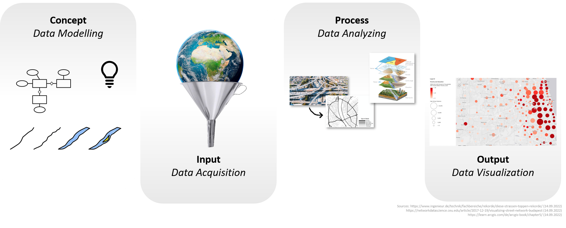
[u]Introduction to Geo-Information Systems (GIS):[/u]
Terminologies and definitions, spatial information / Geo-Information, spatial reference - model of the real world - power of coordinates - , historical development, GIS and LIS, basics of GIS architecture
[u]Geospatial objects and information modelling:[/u]
Geometric dimension and abstraction of modelling, Geo-Information objects (entities, features), raster model/vector model, geometry, topology, factual data and topic, modeling in GIS / spatial information
[u]Spatial reference and spatial reference systems:[/u]
geodetic/cartographic reference system, coordinate systems, spatial reference elements, base-GIS and base-maps – public e.g. ALKIS, ATKIS, private-sector base-GIS;
[u]Spatial data acquisition:[/u]
primary and secondary acquisition methods, digitization and georeferencing / geocoding;
[u]Spatial analysis with GIS:[/u]
Geometric, topological, thematic queries, geometric methods, topological methods, network analyses;
[u]Geovisualization[/u]
[u]Spatial data exchange and Spatial Data Infrastructure (SDI)[/u]
Literature
Bill, Ralf: Grundlagen der Geo-Informationssysteme (German)
Longley, Paul et.al.: Geographic Information Science and Systems (English)
Preconditions
none
Expected Number of Participants
90
Further Information
[b]Qualification goals / learning outcomes of the module[/b]
After students have attended the course, they:
[list]
[*]master basic functions of GIS,
[*]may support projects of urban development with GIS techniques from the beginning of data acquisition, processing, analysing and visualization
[*]have the ability to weigh up different solutions, to explain them objectively and understandably, to make and justify decisions,
[*]can also use GIS for more advanced tasks in urban development and planning such as spatial analysis, catchment area analysis, network analysis, overlaying, etc
[/list]
Online Offerings
The lecture is offered online.
The semester exercises are offered online and in person.
Communication and information provision during the semester takes place exclusively via Moodle.
- Lecturer: Christian Hickel
- Lecturer: Hans-Joachim Linke
- Lecturer: Philipp Müller
- Lecturer: Luisa Ritter